Utah Fly Drive Destination Canyonlands National Park
Area navigation
Map of location
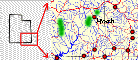
The map to the right is interactive. Hold your mouse pointer over the highlighted places and they will be identified.
Some of the places shown have a web page and can be accessed by clicking on them.
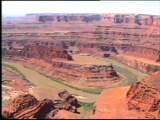
Situated just outside Moab and close to Arches,
Canyonlands has some awesome scenery looking down over where the Green and Colorado rivers meet. Much further downstream they carve out the upper reaches of the Grand Canyon now flooded as Lake Powell. The views here give you an idea of what the terrain flooded under Lake Powell used to look like. Take a
side trip to Dead Horse point state park as you drive into Canyonlands. This has one of the most
memorable views I have seen in America.
The picture to the left is the view into Canyonlands from Dead Horse point. Its hard to snatch yourself away from the amazing view.
If you know something different or additional to the information posted here, please
follow this link and send in your information using the
data entry form.
Go to the top of this page